
Haz una donación
Mapa topográfico Nansang
Haga clic en el mapa para ver la altitud.
Haz una donación
Acerca de este mapa
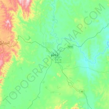
Nombre: Mapa topográfico Nansang, altitud, relieve.
Altitud media: 1 058 m
Altitud mínima: 858 m
Altitud máxima: 1 744 m
Haz una donación
Otros mapas topográficos
Haga clic en un mapa para ver su topografía, su altitud y su relieve.
Haz una donación
Inle Lake
Myanmar > Shan State > Nyaungshwe Township
Inle Lake (Burmese: အင်းလေးကန်; MLCTS: ang: le: kan, [ʔɪ́ɰ̃lé kàɰ̃]), a freshwater lake located in the Nyaungshwe Township of Shan State, part of Shan Hills in Myanmar (Burma). It is the second largest lake in Myanmar, with an estimated surface area of 44.9 square miles (116 km2),…
Altitud media: 1 102 m
Haz una donación
Haz una donación
Haz una donación
Haz una donación
Haz una donación
Kalaw
Myanmar > Shan State > Kalaw Township
The hill station is located at an elevation of 1310 metres, 50 km from the Inle lake. Kalaw is famous for hiking and trekking. Many trekking trails ranging from nearby places to Inle Lake and Pindaya. The town still feels like a high-altitude holiday resort – the air is cool, the atmosphere is calm and the…
Altitud media: 1 348 m
Haz una donación
Mong Hsat Township
Myanmar > Shan State > Mong Hsat District > Mong Hsat Township
Altitud media: 979 m
Haz una donación
Pinlaung Township
Myanmar > Shan State > Taunggyi District > Pinlaung Township
Pinlaung Township accounts for the largest area of tea cultivation in southern Shan State. The Tea grown here is of the Assamica cultivar. Tea plantations in the area cover 12,000 acres, with half of the cultivation taking place in the higher elevations of Le Hlaung, 10 miles from Pinlaung. In the Koe Khaung…
Altitud media: 964 m