
Mapa topográfico Mont Riounet
Mapa interactivo
Haga clic en el mapa para ver la altitud.
Acerca de este mapa
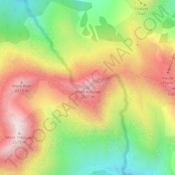
Nombre: Mapa topográfico Mont Riounet, altitud, relieve.
Altitud media: 2 175 m
Altitud mínima: 1 773 m
Altitud máxima: 2 571 m
Otros mapas topográficos
Haga clic en un mapa para ver su topografía, su altitud y su relieve.
Lac de Rabuons
France > Provence-Alpes-Côte d'Azur > Saint-Étienne-de-Tinée
Lac de Rabuons, Les Balcons du Mercantour, Saint-Étienne-de-Tinée, Nice, Alpes-Maritimes, Provence-Alpes-Côte d'Azur, France métropolitaine, 06660, France
Altitud media: 2 650 m
Lac de Rabuons
France > Provence-Alpes-Côte d'Azur > Saint-Étienne-de-Tinée
Lac de Rabuons, Les Balcons du Mercantour, Saint-Étienne-de-Tinée, Nice, Alpes-Maritimes, Provence-Alpes-Côte d'Azur, France métropolitaine, 06660, France
Altitud media: 2 607 m
Plan d'eau des Trinitaires
France > Provence-Alpes-Côte d'Azur > Saint-Étienne-de-Tinée
Plan d'eau des Trinitaires, Sentier de l'Eau, Saint-Étienne-de-Tinée, Nice, Alpes-Maritimes, Provence-Alpes-Côte d'Azur, France métropolitaine, 06660, France
Altitud media: 1 441 m
Lacs de Vens
France > Provence-Alpes-Côte d'Azur > Saint-Étienne-de-Tinée
Lacs de Vens, Chemin de l'Énergie, Saint-Étienne-de-Tinée, Nice, Alpes-Maritimes, Provence-Alpes-Côte d'Azur, France métropolitaine, 06660, France
Altitud media: 2 385 m
Lacs Morgons
France > Provence-Alpes-Côte d'Azur > Saint-Étienne-de-Tinée
Lacs Morgons, M 64, Saint-Étienne-de-Tinée, Nice, Alpes-Maritimes, Provence-Alpes-Côte d'Azur, France métropolitaine, 06660, France
Altitud media: 2 392 m