
Gracias por apoyar a este sitio ❤️
Haz una donación
Haz una donación
Mapa topográfico Sheridan
Haga clic en el mapa para ver la altitud.
Gracias por apoyar a este sitio ❤️
Haz una donación
Haz una donación
Sheridan
The South Yamhill River divides the city between north and south, and is prone to flooding the city. Deer Creek is the only other stream in the city. Sheridan is located in the western part of the Willamette Valley at an elevation of 189 feet (58 m) above sea level. The city lies at the foothills of the Northern Oregon Coast Range.
Gracias por apoyar a este sitio ❤️
Haz una donación
Haz una donación
Acerca de este mapa
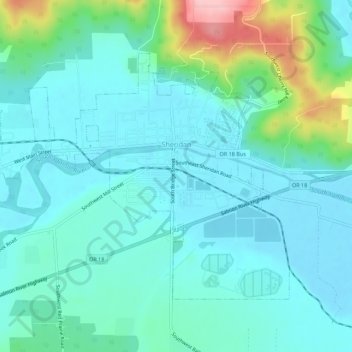
Nombre: Mapa topográfico Sheridan, altitud, relieve.
Lugar: Sheridan, Yamhill County, Oregon, United States (45.08207 -123.43244 45.10937 -123.37708)
Altitud media: 85 m
Altitud mínima: 52 m
Altitud máxima: 217 m
Gracias por apoyar a este sitio ❤️
Haz una donación
Haz una donación
Otros mapas topográficos
Haga clic en un mapa para ver su topografía, su altitud y su relieve.