
Mapa topográfico Council Bluffs
Mapa interactivo
Haga clic en el mapa para ver la altitud.
Council Bluffs
Council Bluffs covers a unique topographic region originally composed of prairie and savanna in the Loess Hills with extensive wetlands and deciduous forest along the Missouri River. Excellent vistas can be had from KOIL Point at Fairmont Park, the Lincoln Monument, Kirn Park, and the Lewis and Clark Monument. Lake Manawa State Park is located at the southern edge of the city.
Acerca de este mapa
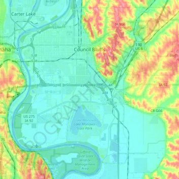
Nombre: Mapa topográfico Council Bluffs, altitud, relieve.
Altitud media: 315 m
Altitud mínima: 291 m
Altitud máxima: 386 m