
Mapa topográfico The Municipal District of Mullingar — Kinnegad
Mapa interactivo
Haga clic en el mapa para ver la altitud.
Acerca de este mapa
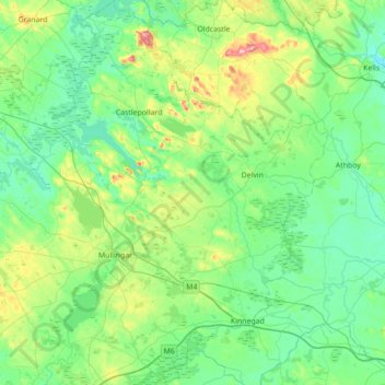
Nombre: Mapa topográfico The Municipal District of Mullingar — Kinnegad, altitud, relieve.
Altitud media: 90 m
Altitud mínima: 47 m
Altitud máxima: 270 m
Otros mapas topográficos
Haga clic en un mapa para ver su topografía, su altitud y su relieve.
Mullingar
Mullingar, The Municipal District of Mullingar — Kinnegad, County Westmeath, Comté de Westmeath, Leinster, Irlande
Altitud media: 99 m
Tullin
Tullin, Moydrum ED, The Municipal District of Athlone — Moate, County Westmeath, Comté de Westmeath, Leinster, Irlande
Altitud media: 42 m
Derry
Derry, Castlelost ED, The Municipal District of Mullingar — Kinnegad, County Westmeath, Comté de Westmeath, Leinster, N91 AE6P, Irlande
Altitud media: 84 m
Portloman ED
Portloman ED, The Municipal District of Athlone — Moate, County Westmeath, Comté de Westmeath, Leinster, Irlande
Altitud media: 100 m
Athlone
Irlande > County Westmeath > Athlone
Athlone, The Municipal District of Athlone — Moate, County Westmeath, Leinster, N37 N1F2, Irlande
Altitud media: 44 m