
Gracias por apoyar a este sitio ❤️
Haz una donación
Haz una donación
Mapa topográfico Milpitas
Haga clic en el mapa para ver la altitud.
Gracias por apoyar a este sitio ❤️
Haz una donación
Haz una donación
Milpitas
The median elevation of Milpitas is 19 feet (6 m). At Piedmont Road, Evans Road, and North Park Victoria Drive, the elevation is generally about 100 feet (30 m), while the western area is almost at sea level. The highest point in Milpitas is a 1,289-foot (393 m) peak in the southeastern foothills.
Gracias por apoyar a este sitio ❤️
Haz una donación
Haz una donación
Acerca de este mapa
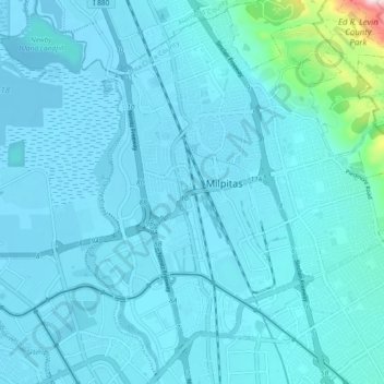
Nombre: Mapa topográfico Milpitas, altitud, relieve.
Altitud media: 47 m
Altitud mínima: -6 m
Altitud máxima: 585 m
Gracias por apoyar a este sitio ❤️
Haz una donación
Haz una donación
Otros mapas topográficos
Haga clic en un mapa para ver su topografía, su altitud y su relieve.