
Gracias por apoyar a este sitio ❤️
Haz una donación
Haz una donación
Mapa topográfico Traverse Bay
Haga clic en el mapa para ver la altitud.
Gracias por apoyar a este sitio ❤️
Haz una donación
Haz una donación
Acerca de este mapa
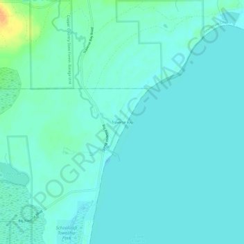
Nombre: Mapa topográfico Traverse Bay, altitud, relieve.
Altitud media: 182 m
Altitud mínima: 176 m
Altitud máxima: 210 m
Gracias por apoyar a este sitio ❤️
Haz una donación
Haz una donación
Otros mapas topográficos
Haga clic en un mapa para ver su topografía, su altitud y su relieve.
Calumet
United States > Michigan > Houghton County
Calumet is at an elevation of 1,209 feet (369 m) above sea level. The village of Calumet sits on 2,000 miles (3,200 km) of underground mine shafts, drifts and stopes, empty for many decades. Large portions of the Keweenaw National Historical Park are located inside the village limits, mostly covering the…
Altitud media: 369 m
Gracias por apoyar a este sitio ❤️
Haz una donación
Haz una donación
Gracias por apoyar a este sitio ❤️
Haz una donación
Haz una donación
Gracias por apoyar a este sitio ❤️
Haz una donación
Haz una donación