
Haz una donación
Mapa topográfico Pinos Altos
Haga clic en el mapa para ver la altitud.
Haz una donación
Acerca de este mapa
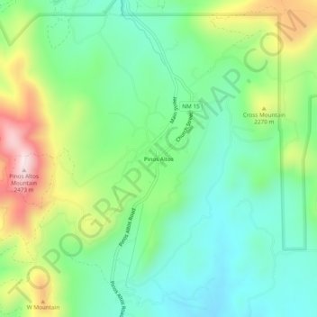
Nombre: Mapa topográfico Pinos Altos, altitud, relieve.
Altitud media: 2 142 m
Altitud mínima: 1 983 m
Altitud máxima: 2 470 m
Haz una donación
Otros mapas topográficos
Haga clic en un mapa para ver su topografía, su altitud y su relieve.
Silver City
United States > New Mexico > Grant County
During the period from 1901 to 1964 when readings were taken at the city center (which is cooler and wetter than outlying and lower-elevation districts nearby), the coldest temperature recorded was −13 °F (−25 °C) on January 11, 1962, and the hottest 105 °F (40.6 °C) on July 5, 1901. The coldest month…
Altitud media: 1 850 m
Bayard
United States > New Mexico > Grant County
Bayard is located in the southern foothills of the Pinos Altos Range and Mogollon Mountains in the southwestern portion of New Mexico and situated east of the Continental Divide at an elevation of approximately 5,800 feet (1,800 m). Gila National Forest lies north from here. A semi-arid desert of predominantly…
Altitud media: 1 816 m
Silver City
United States > New Mexico > Grant County
During the period from 1901 to 1964, when readings were taken at the city center (which is cooler and wetter than outlying and lower-elevation districts nearby), the coldest temperature recorded was −13 °F (−25 °C) on January 11, 1962, and the hottest 105 °F (40.6 °C) on July 5, 1901. The coldest month…
Altitud media: 1 851 m
Haz una donación