
Mapa topográfico Rüthi (SG)
Mapa interactivo
Haga clic en el mapa para ver la altitud.
Acerca de este mapa
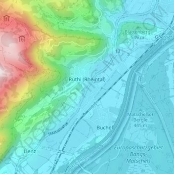
Nombre: Mapa topográfico Rüthi (SG), altitud, relieve.
Lugar: Rüthi (SG), Wahlkreis Rheintal, St. Gallen, Switzerland (47.27661 9.50149 47.31048 9.56558)
Altitud media: 594 m
Altitud mínima: 410 m
Altitud máxima: 1 412 m
Otros mapas topográficos
Haga clic en un mapa para ver su topografía, su altitud y su relieve.
Oberriet
Switzerland > St. Gallen > Wahlkreis Rheintal
Oberriet, Wahlkreis Rheintal, St. Gallen, Switzerland
Altitud media: 528 m
Berneck
Switzerland > St. Gallen > Wahlkreis Rheintal
Berneck, Wahlkreis Rheintal, St. Gallen, 9442, Switzerland
Altitud media: 561 m
Altstätten
Switzerland > St. Gallen > Wahlkreis Rheintal > Altstätten
Altstätten, Wahlkreis Rheintal, St. Gallen, Switzerland
Altitud media: 679 m
Marbach
Switzerland > St. Gallen > Wahlkreis Rheintal > Marbach
Marbach, Wahlkreis Rheintal, St. Gallen, 9437, Switzerland
Altitud media: 448 m