
Mapa topográfico Kilkenny
Mapa interactivo
Haga clic en el mapa para ver la altitud.
Acerca de este mapa
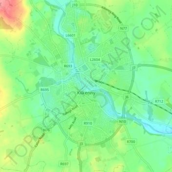
Nombre: Mapa topográfico Kilkenny, altitud, relieve.
Lugar: Kilkenny, Comté de Kilkenny, Leinster, Irlande (52.62761 -7.28545 52.67819 -7.20616)
Altitud media: 62 m
Altitud mínima: 36 m
Altitud máxima: 114 m
Otros mapas topográficos
Haga clic en un mapa para ver su topografía, su altitud y su relieve.
Clomantagh (Mt Garrett)
Clomantagh (Mt Garrett), Clomantagh, The Municipal District of Castlecomer, Comté de Kilkenny, Leinster, Irlande
Altitud media: 217 m
Agha
Agha, Rathcoole, The Municipal District of Castlecomer, Comté de Kilkenny, Leinster, Irlande
Altitud media: 213 m
Tifeaghna (Mt Garrett)
Tifeaghna (Mt Garrett), Lisdowney, The Municipal District of Castlecomer, Comté de Kilkenny, Leinster, Irlande
Altitud media: 145 m
The Municipal District of Kilkenny City
The Municipal District of Kilkenny City, Comté de Kilkenny, Leinster, Irlande
Altitud media: 84 m
Westmoreland
Westmoreland, Aghaviller, The Municipal District of Callan — Thomastown, Comté de Kilkenny, Leinster, Irlande
Altitud media: 134 m