
Haz una donación
Mapa topográfico Nationalpark Harz
Haga clic en el mapa para ver la altitud.
Haz una donación
Nationalpark Harz
Several rivers have their sources in the national park, including the Bode, the Oder and the Ilse, a tributary of the Oker. The waters of the Oder, flowing southwards, are collected in the historic Oderteich reservoir, finished in 1722 to supply the mines in Sankt Andreasberg, and feed the Oder Dam on the southeastern edge of the park. Other dams and lakes within or bordering on the national park include the Ecker Dam and the Silberteich. The highest elevations are the Brocken, the Bruchberg and the Achtermann.
Haz una donación
Acerca de este mapa
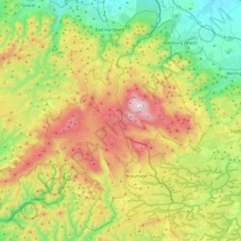
Nombre: Mapa topográfico Nationalpark Harz, altitud, relieve.
Lugar: Nationalpark Harz, Landkreis Goslar, Lower Saxony, Germany (51.66833 10.31921 51.90061 10.72798)
Altitud media: 533 m
Altitud mínima: 167 m
Altitud máxima: 1 139 m
Haz una donación
Otros mapas topográficos
Haga clic en un mapa para ver su topografía, su altitud y su relieve.