
Mapa topográfico Vals
Mapa interactivo
Haga clic en el mapa para ver la altitud.
Acerca de este mapa
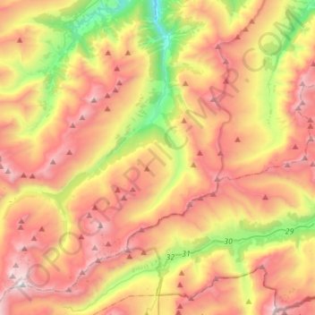
Nombre: Mapa topográfico Vals, altitud, relieve.
Lugar: Vals, Surselva, Grisons, 7132, Switzerland (46.49395 9.01662 46.68213 9.24341)
Altitud media: 2 177 m
Altitud mínima: 969 m
Altitud máxima: 3 332 m
Before 2017, the municipality was located in the Lugnez sub-district of the Surselva district, after 2017 it was part of the Surselva Region. It consists of the village of Vals at an elevation of 1,252 m (4,108 ft) and the hamlets of Leis at an elevation of 1,526 m (5,007 ft)). The highest point of the municipality is reached on Rheinwaldhorn on 3,402 m (11,161 ft).
Otros mapas topográficos
Haga clic en un mapa para ver su topografía, su altitud y su relieve.
Surcuolm
Switzerland > Grisons > Surselva > Obersaxen-Mundaun
Surcuolm, Obersaxen-Mundaun, Surselva, Grisons, 7138, Switzerland
Altitud media: 1 311 m
Vrin
Switzerland > Grisons > Surselva > Lumnezia
Vrin, Lumnezia, Surselva, Grisons, 7149, Switzerland
Altitud media: 1 698 m
Vattiz
Switzerland > Grisons > Surselva > Lumnezia
Vattiz, Lumnezia, Surselva, Grisons, 7146, Switzerland
Altitud media: 1 324 m
Ilanz
Switzerland > Grisons > Surselva > Ilanz/Glion
Ilanz, Ilanz/Glion, Surselva, Grisons, 7130, Switzerland
Altitud media: 952 m
Sevgein
Switzerland > Grisons > Surselva > Ilanz/Glion
Sevgein, Ilanz/Glion, Suraua, Surselva, Grisons, 7127, Switzerland
Altitud media: 973 m
Valendas
Switzerland > Grisons > Surselva > Safiental
Valendas, Safiental, Surselva, Grisons, 7122, Switzerland
Altitud media: 988 m
Lumnezia
Switzerland > Grisons > Surselva
Lumnezia, Surselva, Grisons, Switzerland
Altitud media: 1 900 m