
Mapa topográfico Dromore
Mapa interactivo
Haga clic en el mapa para ver la altitud.
Acerca de este mapa
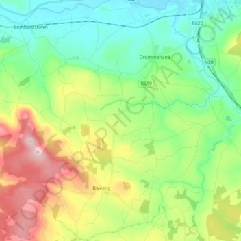
Nombre: Mapa topográfico Dromore, altitud, relieve.
Altitud media: 170 m
Altitud mínima: 46 m
Altitud máxima: 415 m
Otros mapas topográficos
Haga clic en un mapa para ver su topografía, su altitud y su relieve.
Mountbridget
Mountbridget, Churchtown ED, The Municipal District of Kanturk-Mallow, Comté de Cork, Munster, Irlande
Altitud media: 121 m
Ringaskiddy
Ringaskiddy, Municipal District of Carrigaline, Comté de Cork, Munster, P43 A062, Irlande
Altitud media: 13 m
Toormore
Toormore, West Cork, Comté de Cork, Munster, Irlande
Altitud media: 33 m
Bere Island
Bere Island, West Cork, Comté de Cork, Munster, Irlande
Altitud media: 28 m
Castletownroche
Castletownroche, The Municipal District of Fermoy, Comté de Cork, Munster, Irlande
Altitud media: 67 m
Reanascreena South
Reanascreena South, Cahermore ED, West Cork, Comté de Cork, Munster, Irlande
Altitud media: 146 m
Donegal
Irlande > Comté de Cork > Municipal District of Cobh
Donegal, Cobh Rural ED, Municipal District of Cobh, Comté de Cork, Munster, Irlande
Altitud media: 31 m
Municipal District of Carrigaline
Municipal District of Carrigaline, Comté de Cork, Munster, Irlande
Altitud media: 52 m
The Municipal District of Bandon-Kinsale
The Municipal District of Bandon-Kinsale, Comté de Cork, Munster, Irlande
Altitud media: 69 m
Windsor
Irlande > Comté de Cork > Municipal District of Macroom
Windsor, Ballincollig ED, Municipal District of Macroom, Comté de Cork, Munster, Irlande
Altitud media: 150 m
Douglas
Irlande > Comté de Cork > Cork
Douglas, Cork, Comté de Cork, Munster, Irlande
Altitud media: 34 m
Clonakilty Poor Law Union
Clonakilty Poor Law Union, Comté de Cork, Munster, Irlande
Altitud media: 58 m
Ardgroom
Ardgroom, West Cork, Comté de Cork, Munster, Irlande
Altitud media: 56 m