
Mapa topográfico Ann Arbor
Mapa interactivo
Haga clic en el mapa para ver la altitud.
Acerca de este mapa
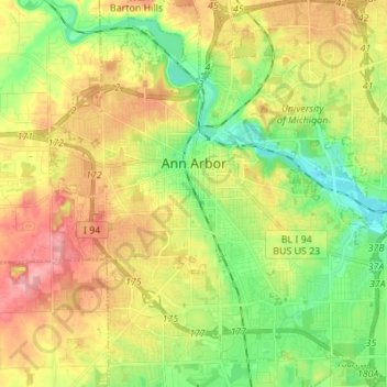
Nombre: Mapa topográfico Ann Arbor, altitud, relieve.
Lugar: Ann Arbor, Washtenaw County, Michigan, United States (42.22267 -83.79957 42.32389 -83.67581)
Altitud media: 268 m
Altitud mínima: 223 m
Altitud máxima: 326 m
Ann Arbor is 11.2 miles (18.0 km) road miles west of Ypsilanti. Ann Arbor is also 42.1 miles (67.8 km) road miles west of Detroit. Ann Arbor Charter Township adjoins the city's north and east sides. Ann Arbor is situated on the Huron River in a productive agricultural and fruit-growing region. The landscape of Ann Arbor consists of hills and valleys, with the terrain becoming steeper near the Huron River. The elevation ranges from about 750 feet (230 m) along the Huron River to 1,015 feet (309 m) on the city's west side, near the intersection of Maple Road and Pauline Blvd. Generally, the west-central and northwestern parts of the city and U-M's North Campus are the highest parts of the city; the lowest parts are along the Huron River and in the southeast. Ann Arbor Municipal Airport, which is south of the city at 42°13.38′N 83°44.74′W / 42.22300°N 83.74567°W / 42.22300; -83.74567, has an elevation of 839 feet (256 m).
Otros mapas topográficos
Haga clic en un mapa para ver su topografía, su altitud y su relieve.
Scio Township
United States > Michigan > Washtenaw County
Scio Township, Washtenaw County, Michigan, United States
Altitud media: 277 m
Saline
United States > Michigan > Washtenaw County
Saline, Washtenaw County, Michigan, 48176, United States
Altitud media: 248 m
Lyndon Township
United States > Michigan > Washtenaw County
Lyndon Township, Washtenaw County, Michigan, 48190, United States
Altitud media: 288 m
Ypsilanti
United States > Michigan > Washtenaw County
Ypsilanti, Washtenaw County, Michigan, 48197, United States
Altitud media: 230 m
Dexter Township
United States > Michigan > Washtenaw County > Dexter Township
Dexter Township, Washtenaw County, Michigan, United States
Altitud media: 278 m