
Mapa topográfico Cossonay
Mapa interactivo
Haga clic en el mapa para ver la altitud.
Acerca de este mapa
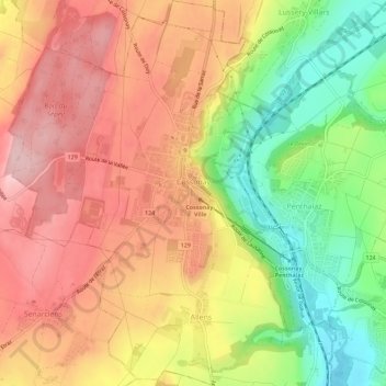
Nombre: Mapa topográfico Cossonay, altitud, relieve.
Lugar: Cossonay, District de Morges, Vaud, 1304, Switzerland (46.59312 6.48170 46.63212 6.52271)
Altitud media: 533 m
Altitud mínima: 415 m
Altitud máxima: 627 m
Cossonay lies at an elevation of 562 m (1,844 ft) and 14 km (8.7 mi) northwest of Lausanne. The town stretches across the high plateau west of the Venoge, about 130 m (430 ft) above the valley floor, in the Gros de Vaud in the middle of the canton of Vaud.
Otros mapas topográficos
Haga clic en un mapa para ver su topografía, su altitud y su relieve.
Saint-Prex
Switzerland > Vaud > District de Morges
Saint-Prex, District de Morges, Vaud, 1162, Switzerland
Altitud media: 398 m
Mont Tendre
Switzerland > Vaud > District de Morges > Montricher
Mont Tendre, Montricher, District de Morges, Vaud, 1147, Switzerland
Altitud media: 1 508 m
Morges
Switzerland > Vaud > District de Morges > Morges > Morges
Morges, District de Morges, Vaud, 1110, Switzerland
Altitud media: 418 m
Morges
Switzerland > Vaud > District de Morges
Morges, District de Morges, Vaud, 1110, Switzerland
Altitud media: 396 m