
Mapa topográfico Fredericton
Mapa interactivo
Haga clic en el mapa para ver la altitud.
Acerca de este mapa
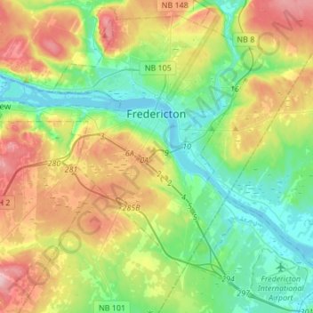
Nombre: Mapa topográfico Fredericton, altitud, relieve.
Lugar: Fredericton, New Brunswick, Canada (45.84701 -66.78340 46.02757 -66.51199)
Altitud media: 69 m
Altitud mínima: -2 m
Altitud máxima: 196 m
At an altitude of about 17 m (56 ft) above sea level, Fredericton is nestled in the Pennsylvanian Basin. It differs markedly from the geologically older parts of the province. There are prominently two distinct areas in the region that are divided around the area of Wilsey Road, in the east end of the city. In the west side, the bedrock underneath the earth is topographically dominant, whereas the other is controlled by Pleistocene and recent deposits leading to the rivers (resulting in the area being shallow and wide). Fredericton and its surroundings are rich in water resources, which, coupled with highly arable soil, make the Fredericton region ideal for agriculture. The Saint John River and one of its major tributaries, the Nashwaak River, come together in Fredericton. The uninhabited parts of the city are heavily forested.
Otros mapas topográficos
Haga clic en un mapa para ver su topografía, su altitud y su relieve.
Richibucto Road
Canada > New Brunswick > York County > Richibucto Road
Richibucto Road, Saint Marys Parish, York County, New Brunswick, E3A 6W1, Canada
Altitud media: 48 m
Dumfries Parish
Canada > New Brunswick > York County
Dumfries Parish, York County, New Brunswick, Canada
Altitud media: 147 m