
Gracias por apoyar a este sitio ❤️
Haz una donación
Haz una donación
Mapa topográfico Worcester County
Haga clic en el mapa para ver la altitud.
Gracias por apoyar a este sitio ❤️
Haz una donación
Haz una donación
Worcester County
The terrain is mostly level and coastal. The lowest elevation is sea level along the Atlantic Ocean and the highest elevation is 49 ft (15 m) in the northwestern part of the county along State Route 12 just south of the Wicomico County line.
Gracias por apoyar a este sitio ❤️
Haz una donación
Haz una donación
Acerca de este mapa
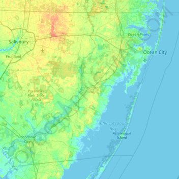
Nombre: Mapa topográfico Worcester County, altitud, relieve.
Lugar: Worcester County, Maryland, United States (37.99428 -75.66177 38.45204 -74.98520)
Altitud media: 6 m
Altitud mínima: -3 m
Altitud máxima: 28 m
Gracias por apoyar a este sitio ❤️
Haz una donación
Haz una donación
Otros mapas topográficos
Haga clic en un mapa para ver su topografía, su altitud y su relieve.