
Haz una donación
Mapa topográfico Binghamton
Haga clic en el mapa para ver la altitud.
Haz una donación
Binghamton
Binghamton, like all of the Southern Tier of New York, lies on the Allegheny Plateau; hence its hilly terrain. As such, elevations can vary in the city--Downtown, for example, is at an elevation of around 860 feet (262 meters), while residential homes in the hills can go up to over 1,800 feet (548 meters), such as on Ingram Hill. The highest peak in Binghamton is Table Rock Ridge, which is at 1,854 feet.
Haz una donación
Acerca de este mapa
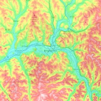
Nombre: Mapa topográfico Binghamton, altitud, relieve.
Altitud media: 397 m
Altitud mínima: 242 m
Altitud máxima: 597 m
Haz una donación
Otros mapas topográficos
Haga clic en un mapa para ver su topografía, su altitud y su relieve.
State University of New York at Binghamton
United States > New York > Broome County > Town of Vestal
Altitud media: 320 m
Haz una donación
Haz una donación
Kopernik Observatory & Science Center
United States > New York > Broome County > Town of Vestal > Tracy Creek
Altitud media: 452 m
Haz una donación
Oquaga Creek State Park
United States > New York > Broome County > Town of Sanford
Altitud media: 533 m