
Haz una donación
Mapa topográfico Schüttorf
Haga clic en el mapa para ver la altitud.
Haz una donación
Schüttorf
The town of Schüttorf lies mainly on valley sand plates which are crossed by the Vechte Lowland, which is almost flush with them along this stretch. The lowland lies roughly 30 m above sea level and is from 200 to 500 m wide. Bordering its edges are river terraces with a height of roughly 35 m above sea level. Owing to the slight difference in elevation even within the river valley, the middle Vechte meandered in the past, leading to the formation of many backwaters. Since then, however, the river has been straightened and is kept at Schüttorf level.
Haz una donación
Acerca de este mapa
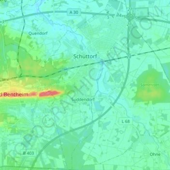
Nombre: Mapa topográfico Schüttorf, altitud, relieve.
Altitud media: 39 m
Altitud mínima: 28 m
Altitud máxima: 89 m
Haz una donación
Otros mapas topográficos
Haga clic en un mapa para ver su topografía, su altitud y su relieve.
Hagelshoek
Germany > Lower Saxony > Landkreis Grafschaft Bentheim > Bad Bentheim > Gildehaus
Altitud media: 48 m