
Haz una donación
Mapa topográfico Mount Meron
Haga clic en el mapa para ver la altitud.
Haz una donación
Mount Meron
In 1965, an 84,000-dunam nature reserve was declared. An additional 1,199 dunams were declared part of the reserve in 2005. It is the highest reserve in Israel, at an altitude of 1,204 meters above sea level, and the largest reserve in the north of the country.
Haz una donación
Acerca de este mapa
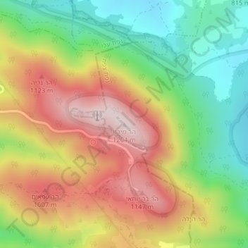
Nombre: Mapa topográfico Mount Meron, altitud, relieve.
Altitud media: 943 m
Altitud mínima: 717 m
Altitud máxima: 1 194 m
Haz una donación
Otros mapas topográficos
Haga clic en un mapa para ver su topografía, su altitud y su relieve.
Meron
Israel > North District > Merom HaGalil Regional Council
Meron is noted for its mountainous terrain and valleys. Among the local attractions are the Meron Vineyards. Meron is conducive to growing grapes for wine as a result of its 600-meter altitude and chalky soil. The vineyard was first planted in 2000 and is part of the Galil Mountain Winery, headquartered in…
Altitud media: 735 m
Haz una donación