
Gracias por apoyar a este sitio ❤️
Haz una donación
Haz una donación
Mapa topográfico Asientos
Haga clic en el mapa para ver la altitud.
Gracias por apoyar a este sitio ❤️
Haz una donación
Haz una donación
Asientos
The municipality of Asientos is located in the north-east of the state and has a territorial area of 547.74 kilometres squared which is equivalent to 9.84% of the total area of the state and it has an altitude ranging from 1800 to 2700 metres above sea level.
Gracias por apoyar a este sitio ❤️
Haz una donación
Haz una donación
Acerca de este mapa
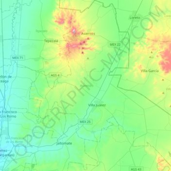
Nombre: Mapa topográfico Asientos, altitud, relieve.
Lugar: Asientos, Aguascalientes, Mexico (21.95839 -102.21933 22.30607 -101.85416)
Altitud media: 2 042 m
Altitud mínima: 1 871 m
Altitud máxima: 2 633 m
Gracias por apoyar a este sitio ❤️
Haz una donación
Haz una donación
Otros mapas topográficos
Haga clic en un mapa para ver su topografía, su altitud y su relieve.