
Haz una donación
Mapa topográfico Upper Geyser Basin
Haga clic en el mapa para ver la altitud.
Haz una donación
Acerca de este mapa
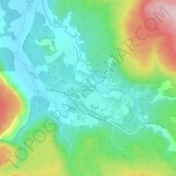
Nombre: Mapa topográfico Upper Geyser Basin, altitud, relieve.
Altitud media: 2 295 m
Altitud mínima: 2 213 m
Altitud máxima: 2 485 m
Haz una donación
Otros mapas topográficos
Haga clic en un mapa para ver su topografía, su altitud y su relieve.
Grand Teton National Park
United States > Wyoming > Teton County
Grand Teton National Park is named for Grand Teton, the tallest mountain in the Teton Range. The naming of the mountains is attributed to early 19th-century French-speaking trappers—les trois tétons (the three teats) was later anglicized and shortened to Tetons. At 13,775 feet (4,199 m), Grand Teton…
Altitud media: 2 409 m
Haz una donación
Grand Teton National Park
United States > Wyoming > Teton County
Grand Teton National Park is named for Grand Teton, the tallest mountain in the Teton Range. At 13,775 feet (4,199 m), Grand Teton rises more than 7,000 feet (2,100 m) above Jackson Hole. The park has numerous lakes, including 15-mile-long (24 km) Jackson Lake as well as streams and the upper main stem of the…
Altitud media: 2 409 m
Jackson
United States > Wyoming > Teton County
Jackson is located at 43°28′31″N 110°46′9″W / 43.47528°N 110.76917°W / 43.47528; -110.76917 (43.475, −110.769), at an elevation of 6,237 feet (1,901 m) above sea level. According to the United States Census Bureau, the town has a total area of 2.95 square miles (7.64 km2), of which 2.91…
Altitud media: 2 043 m
Haz una donación
Jackson
United States > Wyoming > Teton County
Jackson is located at an elevation of 6,237 feet (1,901 m) above sea level. According to the United States Census Bureau, the town has a total area of 3.009 square miles (7.79 km2), of which 2.978 square miles (7.71 km2) is land and 0.031 square miles (0.08 km2) (1.03%) is water.
Altitud media: 2 043 m
Jenny Lake
United States > Wyoming > Teton County
Jenny Lake is a starting point for many day and overnight hiking trips. The 7.1-mile (11.4 km) Jenny Lake Trail loops around the lake and is considered to be relatively easy due to the small altitude gain of 700 feet (210 m). However, the altitude increases rapidly once Cascade Canyon is entered.
Altitud media: 2 109 m
Haz una donación
Wilson
United States > Wyoming > Teton County > Wilson
Wilson is located at 43°29′11″N 110°52′45″W / 43.48639°N 110.87917°W / 43.48639; -110.87917 (43.4863, -110.8793). at an elevation of 6,148 feet (1,874 m) above sea level.
Altitud media: 2 208 m
Haz una donación
Jackson
United States > Wyoming > Teton County
Jackson is located at 43°28′31″N 110°46′9″W / 43.47528°N 110.76917°W / 43.47528; -110.76917 (43.475, −110.769), at an elevation of 6,237 feet (1,901 m) above sea level. According to the United States Census Bureau, the town has a total area of 2.95 square miles (7.64 km2), of which 2.91…
Altitud media: 2 043 m