
Gracias por apoyar a este sitio ❤️
Haz una donación
Haz una donación
Mapa topográfico Teutoburg Forest
Haga clic en el mapa para ver la altitud.
Gracias por apoyar a este sitio ❤️
Haz una donación
Haz una donación
Teutoburg Forest
The highest elevation in the Southern Teutoburg Forest is the Velmerstot (468 m or 1,535 ft) south of Horn-Bad Meinberg. In the Northern Teutoburg Forest the highest elevation is the Dörenberg (331 m or 1,086 ft) north of Bad Iburg.
Gracias por apoyar a este sitio ❤️
Haz una donación
Haz una donación
Acerca de este mapa
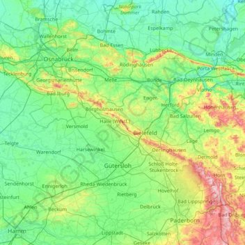
Nombre: Mapa topográfico Teutoburg Forest, altitud, relieve.
Altitud media: 105 m
Altitud mínima: 31 m
Altitud máxima: 462 m
Gracias por apoyar a este sitio ❤️
Haz una donación
Haz una donación
Otros mapas topográficos
Haga clic en un mapa para ver su topografía, su altitud y su relieve.
Emsquelle
Germany > North Rhine-Westphalia > Kreis Gütersloh > Schloß Holte-Stukenbrock
Altitud media: 135 m