
Haz una donación
Mapa topográfico Thomas Lake
Haga clic en el mapa para ver la altitud.
Haz una donación
Acerca de este mapa
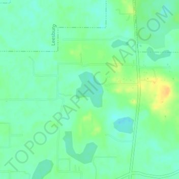
Nombre: Mapa topográfico Thomas Lake, altitud, relieve.
Lugar: Thomas Lake, Lake County, Florida, United States (28.68833 -81.90580 28.69381 -81.90101)
Altitud media: 30 m
Altitud mínima: 20 m
Altitud máxima: 46 m
Haz una donación
Otros mapas topográficos
Haga clic en un mapa para ver su topografía, su altitud y su relieve.
Montverde
United States > Florida > Lake County
Montverde is located in southeastern Lake County at 28°35′58″N 81°40′34″W / 28.599476°N 81.676221°W / 28.599476; -81.676221, on the southwest shore of Lake Apopka. The town sits on hills that rise 50 to 100 feet (15 to 30 m) above the elevation of the lake. It is 18 miles (29 km) south of…
Altitud media: 27 m
Haz una donación
Haz una donación
Lake Harris
United States > Florida > Lake County > Howey-in-the-Hills
Lake Harris' primary inflow is at its southwestern shore from the Palatlakaha River, which originates from the Clermont chain of lakes to the south. Other inflowing rivers include Helena Run and discharge from many small springs in Yalaha. Lake Harris' depth is much greater than Lake Okeechobee to the south,…
Altitud media: 25 m
Haz una donación
Haz una donación
Haz una donación