
Mapa topográfico Prato (Leventina)
Mapa interactivo
Haga clic en el mapa para ver la altitud.
Acerca de este mapa
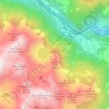
Nombre: Mapa topográfico Prato (Leventina), altitud, relieve.
Altitud media: 1 755 m
Altitud mínima: 801 m
Altitud máxima: 2 688 m
The municipality is located in the Leventina district, in a depression in the mountains at an elevation of 1,046 m (3,432 ft) near the Monte Piottino gorge. It consists of the village of Prato and the hamlets of Fiesso, Mascengo, Rodi and Morasco.
Otros mapas topográficos
Haga clic en un mapa para ver su topografía, su altitud y su relieve.
Sobrio
Switzerland > Ticino > Distretto di Leventina > Sobrio
Sobrio, Faido, Circolo di Giornico, Distretto di Leventina, Ticino, 6749, Switzerland
Altitud media: 1 112 m
Ambrì
Switzerland > Ticino > Distretto di Leventina
Ambrì, Quinto, Circolo di Quinto, Distretto di Leventina, Ticino, 6775, Switzerland
Altitud media: 1 459 m