
Mapa topográfico Elliott Knob
Mapa interactivo
Haga clic en el mapa para ver la altitud.
Acerca de este mapa
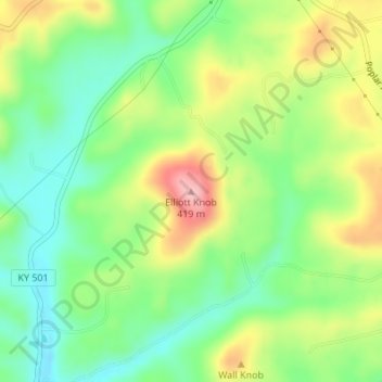
Nombre: Mapa topográfico Elliott Knob, altitud, relieve.
Lugar: Elliott Knob, Casey County, Kentucky, USA (37.28114 -84.86111 37.28124 -84.86101)
Altitud media: 323 m
Altitud mínima: 262 m
Altitud máxima: 415 m
Otros mapas topográficos
Haga clic en un mapa para ver su topografía, su altitud y su relieve.
Daniel Boone National Forest
Daniel Boone National Forest, Forest Road, Lakes, Jackson County, Kentucky, USA
Altitud media: 341 m
Herrington Lake
USA > Kentucky > Little Needmore
Herrington Lake, Taylor Road, Little Needmore, Boyle County, Kentucky, USA
Altitud media: 261 m
Floyds Fork
USA > Kentucky > Louisville
Floyds Fork, Louisville, Jefferson County, Kentucky, 40023, USA
Altitud media: 191 m
Grayson Lake
Grayson Lake, Horton Flats Road, Bruin, Elliott County, Kentucky, USA
Altitud media: 263 m
Basil Lewis Park
Basil Lewis Park, Latonia, Covington, Kenton County, Kentucky, USA
Altitud media: 163 m
Stringtown
USA > Kentucky > Stringtown
Stringtown, Boone County, Kentucky, 45233, USA
Altitud media: 215 m
Johnsonville
USA > Kentucky > Johnsonville
Johnsonville, Anderson County, Kentucky, USA
Altitud media: 228 m
Fishtrap Lake
Fishtrap Lake, Island Creek Road, Phyllis, Pike County, Kentucky, 41554, USA
Altitud media: 402 m
Abraham Lincoln Birthplace National Historic Site
USA > Kentucky > Boundary Oak
Abraham Lincoln Birthplace National Historic Site, Boundary Oak, Larue County, Kentucky, USA
Altitud media: 238 m
Coxs Creek
USA > Kentucky > Coxs Creek
Coxs Creek, Nelson County, Kentucky, 40013, USA
Altitud media: 197 m
Falling Branch
USA > Kentucky > Falling Branch
Falling Branch, Grayson County, Kentucky, 40119, USA
Altitud media: 171 m
Harrods Creek
USA > Kentucky > Harrods Creek
Harrods Creek, Jefferson County, Kentucky, 40059, USA
Altitud media: 154 m
Cumberland Island
Cumberland Island, Livingston County, Kentucky, USA
Altitud media: 100 m
Reynolds Mountain
Reynolds Mountain, Harlan County, Kentucky, 40863, USA
Altitud media: 685 m
William Whitley House State Shrine
USA > Kentucky > Sugar Grove
William Whitley House State Shrine, Sugar Grove, Lincoln County, Kentucky, USA
Altitud media: 284 m
General James Taylor Park
General James Taylor Park, Newport, Campbell County, Kentucky, USA
Altitud media: 158 m
Beargrass Creek
USA > Kentucky > Louisville
Beargrass Creek, Louisville, Jefferson County, Kentucky, USA
Altitud media: 143 m
Green River Lake
Green River Lake, Hayes Lane, Atchison, Taylor County, Kentucky, USA
Altitud media: 242 m
Raven Run Nature Sanctuary
Raven Run Nature Sanctuary, Lexington, Fayette County, Kentucky, USA
Altitud media: 266 m