
Mapa topográfico Kayseri
Mapa interactivo
Haga clic en el mapa para ver la altitud.
Acerca de este mapa
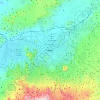
Nombre: Mapa topográfico Kayseri, altitud, relieve.
Altitud media: 1 345 m
Altitud mínima: 1 013 m
Altitud máxima: 2 795 m
Kayseri sits at the foot of Mount Erciyes (Turkish: Erciyes Dağı), a dormant volcano that reaches an altitude of 3,916 metres (12,848 feet), more than 1,500 metres above the city's mean altitude. It contains a number of historic monuments, particularly from the Seljuk period. Tourists often pass through Kayseri en route to the attractions of Cappadocia to the west.