
Mapa topográfico Davos
Mapa interactivo
Haga clic en el mapa para ver la altitud.
Acerca de este mapa
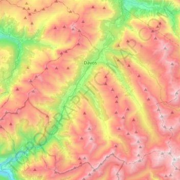
Nombre: Mapa topográfico Davos, altitud, relieve.
Lugar: Davos, Prättigau/Davos, Grisons, Switzerland (46.67026 9.66912 46.85966 9.96706)
Altitud media: 2 142 m
Altitud mínima: 994 m
Altitud máxima: 3 177 m
The main village of Davos lies at the top of the narrow valley of the Landwasser at an altitude of 1,560 metres (5,120 ft), just below the Wolfgang Pass. Lake Davos is northeast of the village, formerly the source of the Landwasser.
Otros mapas topográficos
Haga clic en un mapa para ver su topografía, su altitud y su relieve.
Davosersee
Switzerland > Grisons > Prättigau/Davos > Davos
Davosersee, Davos Dorf, Davos, Prättigau/Davos, Grisons, Switzerland
Altitud media: 1 722 m
Landwasser
Switzerland > Grisons > Prättigau/Davos > Davos
Landwasser, Davos, Prättigau/Davos, Grisons, 7277, Switzerland
Altitud media: 2 063 m
Davos
Switzerland > Grisons > Prättigau/Davos > Davos > Davos
Davos, Prättigau/Davos, Grisons, 7270, Switzerland
Altitud media: 2 007 m
Klosters
Switzerland > Grisons > Prättigau/Davos
Klosters, Prättigau/Davos, Grisons, Switzerland
Altitud media: 2 217 m