
Haz una donación
Mapa topográfico Saxton
Haga clic en el mapa para ver la altitud.
Haz una donación
Acerca de este mapa
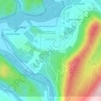
Nombre: Mapa topográfico Saxton, altitud, relieve.
Lugar: Saxton, Bedford County, Pennsylvania, 16678, United States (40.20593 -78.25777 40.21872 -78.23948)
Altitud media: 317 m
Altitud mínima: 240 m
Altitud máxima: 532 m
Haz una donación
Otros mapas topográficos
Haga clic en un mapa para ver su topografía, su altitud y su relieve.
New Enterprise
United States > Pennsylvania > Bedford County > South Woodbury Township
Altitud media: 397 m
Blue Knob
United States > Pennsylvania > Bedford County > Pavia Township
Blue Knob (elevation 3,146 feet (959 m)) is a summit in the eastern United States with a broad dome that is the northernmost 3,000-footer in the Allegheny Mountains. It is the highest point in Bedford County, Pennsylvania.
Altitud media: 792 m
Breezewood
United States > Pennsylvania > Bedford County > East Providence Township
Altitud media: 413 m
Haz una donación
Texas Corner
United States > Pennsylvania > Bedford County > South Woodbury Township
Altitud media: 462 m
Waterside
United States > Pennsylvania > Bedford County > South Woodbury Township
Altitud media: 431 m
Haz una donación
Chaneysville
United States > Pennsylvania > Bedford County > Southampton Township
Altitud media: 373 m
Yellow Creek
United States > Pennsylvania > Bedford County > Hopewell Township > Yellow Creek
Altitud media: 323 m
Haz una donación
Blue Knob
United States > Pennsylvania > Bedford County > Pavia Township
Blue Knob (elevation 3,146 feet (959 m)) is a summit in the eastern United States with a broad dome that is the northernmost 3,000-footer in the Allegheny Mountains. It is the highest point in Bedford County, Pennsylvania.
Altitud media: 792 m