
Gracias por apoyar a este sitio ❤️
Haz una donación
Haz una donación
Mapa topográfico Rudelzhausen
Haga clic en el mapa para ver la altitud.
Gracias por apoyar a este sitio ❤️
Haz una donación
Haz una donación
Acerca de este mapa
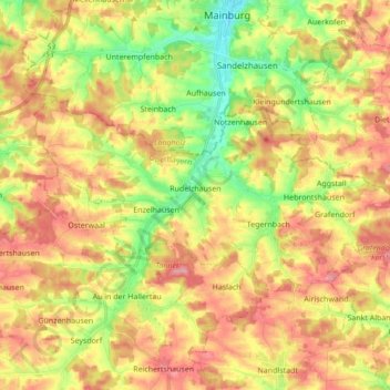
Nombre: Mapa topográfico Rudelzhausen, altitud, relieve.
Lugar: Rudelzhausen, Landkreis Freising, Bavaria, 84104, Germany (48.55951 11.69661 48.61632 11.86843)
Altitud media: 476 m
Altitud mínima: 419 m
Altitud máxima: 526 m
Gracias por apoyar a este sitio ❤️
Haz una donación
Haz una donación
Otros mapas topográficos
Haga clic en un mapa para ver su topografía, su altitud y su relieve.