
Haz una donación
Mapa topográfico Sidonia
Haga clic en el mapa para ver la altitud.
Haz una donación
Acerca de este mapa
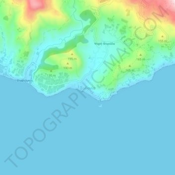
Nombre: Mapa topográfico Sidonia, altitud, relieve.
Altitud media: 58 m
Altitud mínima: 0 m
Altitud máxima: 379 m
Haz una donación
Otros mapas topográficos
Haga clic en un mapa para ver su topografía, su altitud y su relieve.
Knossos Palace
Greece > Region of Crete > Heraklion Regional Unit > Heraklion Municipal Unit
The identification of Knossos with the Bronze Age site is supported by the Roman coins that were scattered over the fields surrounding the pre-excavation site, then a large mound named Kephala Hill, elevation 85 m (279 ft) from current sea level. Many of them were inscribed with Knosion or Knos on the obverse…
Altitud media: 151 m
Municipality of Minoa Pediados
Greece > Region of Crete > Heraklion Regional Unit
Altitud media: 438 m
Haz una donación
Nea Alikarnassos Municipal Unit
Greece > Region of Crete > Heraklion Regional Unit
Altitud media: 64 m
2nd Community of Heraklion - Eastern
Greece > Region of Crete > Heraklion Regional Unit > Heraklion Municipal Unit
Altitud media: 29 m
Haz una donación