
Haz una donación
Mapa topográfico Ventura County
Haga clic en el mapa para ver la altitud.
Haz una donación
Ventura County
Ventura County can be separated into two major parts, East County and West County, which are divided by the Conejo Grade. East County consists of all cities east of the Conejo Grade. Geographically East County is the end of the Santa Monica Mountains, in which the Conejo Valley is located, and where there is a considerable increase in elevation. Communities which are considered to be in the East County are Thousand Oaks, Newbury Park, Lake Sherwood, Hidden Valley, Santa Rosa Valley, part of Westlake Village, Oak Park, Moorpark, and Simi Valley. A majority of these communities are in the Conejo Valley.
Haz una donación
Acerca de este mapa
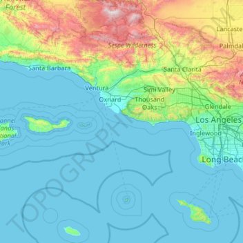
Nombre: Mapa topográfico Ventura County, altitud, relieve.
Lugar: Ventura County, California, United States (33.16349 -119.75770 34.90127 -118.63249)
Altitud media: 331 m
Altitud mínima: -1 m
Altitud máxima: 2 671 m
Haz una donación
Otros mapas topográficos
Haga clic en un mapa para ver su topografía, su altitud y su relieve.
Haz una donación
Mount Shasta
United States > California > Siskiyou County
Mount Shasta (/ˈʃæstə/ SHASS-tə; Shasta: Waka-nunee-Tuki-wuki; Karuk: Úytaahkoo) is a potentially active volcano at the southern end of the Cascade Range in Siskiyou County, California. At an elevation of 14,179 ft (4,322 m), it is the second-highest peak in the Cascades and the fifth-highest in the…
Altitud media: 3 717 m
Haz una donación
Haz una donación
Live Oak
United States > California > Santa Cruz County
Live Oak is a census-designated place (CDP) in Santa Cruz County, California between the cities of Santa Cruz and Capitola and north of the former Union Pacific railroad. Live Oak sits at an elevation of 102 feet (31 m). The population was 17,038 at the 2020 census. The population of the greater Live Oak area,…
Altitud media: 50 m
Haz una donación
Friant
United States > California > Fresno County
Friant (formerly, Converse Ferry, Jones Ferry, Hamptonville, and Pollasky) is a census-designated place (CDP) in Fresno County, California, United States. The population was 549 at the 2010 census, down from 778 at the 2000 census. Friant is located 11.5 miles (19 km) north of Clovis, at an elevation of 344…
Altitud media: 135 m
Haz una donación
Point Dume
United States > California > Los Angeles County > Malibu
Offshore, the nutrient-rich and frigid waters of the Pacific enhance the entire marine food web, from primary producers such as algae and zooplankton to apex predators like sand sharks, bottlenose dolphins, and gray whales. Within the Marine Protected Areas (MPAs), the diverse seafloor topography encompasses…
Altitud media: 12 m
Haz una donación
Rancho Cordova
United States > California > Sacramento County
In the Gold Rush era of mid-19th-century California, certain Placer mining activities took place in the Rancho Cordova environs, some traces of which disturbance are extant. The elevation of the generally level terrain is approximately 118 feet (36 m) above mean sea level.[8] Lone Star Gravel Company and other…
Altitud media: 31 m
Foster Lake
United States > California > Riverside County > Idyllwild-Pine Cove
Altitud media: 1 832 m
Haz una donación
San Carlos
United States > California > San Mateo County > San Carlos > San Carlos
Altitud media: 47 m
Haz una donación