
Gracias por apoyar a este sitio ❤️
Haz una donación
Haz una donación
Mapa topográfico Watervale
Haga clic en el mapa para ver la altitud.
Gracias por apoyar a este sitio ❤️
Haz una donación
Haz una donación
Acerca de este mapa
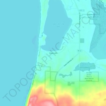
Nombre: Mapa topográfico Watervale, altitud, relieve.
Altitud media: 191 m
Altitud mínima: 170 m
Altitud máxima: 293 m
Gracias por apoyar a este sitio ❤️
Haz una donación
Haz una donación
Otros mapas topográficos
Haga clic en un mapa para ver su topografía, su altitud y su relieve.
Gracias por apoyar a este sitio ❤️
Haz una donación
Haz una donación
Platte Lake
United States > Michigan > Benzie County
Platte Lake is located in Benzie County, which was molded into a land full of sand dunes by the glacial formations. Along with the sand dunes, the glaciers also left many lakes in the area, not only in Benzie but throughout the area. Platte Lake is located at an elevation of 584 feet (178 meters) above sea…
Altitud media: 185 m
Gracias por apoyar a este sitio ❤️
Haz una donación
Haz una donación