
Mapa topográfico Jackson Hole
Haga clic en el mapa para ver la altitud.
Acerca de este mapa
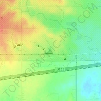
Nombre: Mapa topográfico Jackson Hole, altitud, relieve.
Lugar: Jackson Hole, Comanche County, Oklahoma, United States (34.64027 -98.67810 34.64194 -98.67566)
Altitud media: 406 m
Altitud mínima: 384 m
Altitud máxima: 427 m
Otros mapas topográficos
Haga clic en un mapa para ver su topografía, su altitud y su relieve.
Lawton
United States > Oklahoma > Comanche County
Developed on former reservation lands of the Kiowa, Comanche, and Apache Indians, Lawton was founded by European Americans on 6 August 1901. It was named after Major General Henry Ware Lawton, who served in the Civil War, where he earned the Medal of Honor, and was killed in action in the Philippine–American…
Altitud media: 352 m
Wichita Mountains National Wildlife Refuge
United States > Oklahoma > Comanche County > Medicine Park
Altitud media: 498 m
Lawton
United States > Oklahoma > Comanche County
Developed on former reservation lands of the Kiowa, Comanche, and Apache peoples, Lawton was incorporated in 1901. It was named after Major General Henry Ware Lawton, who served in the Civil War, where he earned the Medal of Honor, and was killed in action in the Philippine–American War. Lawton's landscape…
Altitud media: 352 m