
Mapa topográfico Val-d'Illiez
Mapa interactivo
Haga clic en el mapa para ver la altitud.
Acerca de este mapa
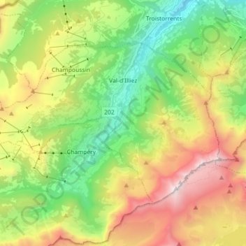
Nombre: Mapa topográfico Val-d'Illiez, altitud, relieve.
Lugar: Val-d'Illiez, Monthey, Wallis, 1873, Switzerland (46.15516 6.80699 46.21897 6.94807)
Altitud media: 1 672 m
Altitud mínima: 649 m
Altitud máxima: 3 247 m
Otros mapas topográficos
Haga clic en un mapa para ver su topografía, su altitud y su relieve.
Lac de Taney
Switzerland > Wallis > Monthey > Vouvry > Taney
Lac de Taney, Taney, Vouvry, Monthey, Wallis, 1896, Switzerland
Altitud media: 1 430 m
Troistorrents
Switzerland > Wallis > Monthey
Troistorrents, Monthey, Wallis, Switzerland
Altitud media: 1 231 m
Champéry
Switzerland > Wallis > Monthey
Champéry, Monthey, Wallis, 1874, Switzerland
Altitud media: 1 883 m
Saint-Gingolph
Switzerland > Wallis > Monthey > Saint-Gingolph
Saint-Gingolph, Monthey, Wallis, 1898, Switzerland
Altitud media: 1 104 m