
Gracias por apoyar a este sitio ❤️
Haz una donación
Haz una donación
Mapa topográfico Vermont Heights
Haga clic en el mapa para ver la altitud.
Gracias por apoyar a este sitio ❤️
Haz una donación
Haz una donación
Vermont Heights
Vermont Heights is located at 29°48′36″N 81°23′50″W / 29.81°N 81.3972°W / 29.81; -81.3972 (29.81, -81.3972) Elevation of 46 Feet. Vermont Heights is the location of the Coquina Crossing Mobile Home Park and St. Augustine Community School of Performing Arts, both of which give their addresses as being in Elkton to the southwest.
Gracias por apoyar a este sitio ❤️
Haz una donación
Haz una donación
Acerca de este mapa
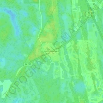
Nombre: Mapa topográfico Vermont Heights, altitud, relieve.
Altitud media: 13 m
Altitud mínima: 6 m
Altitud máxima: 18 m
Gracias por apoyar a este sitio ❤️
Haz una donación
Haz una donación
Otros mapas topográficos
Haga clic en un mapa para ver su topografía, su altitud y su relieve.
Castillo de San Marcos
United States > Florida > Saint Johns County > Saint Augustine
Altitud media: 2 m
Julington Creek Plantation Park
United States > Florida > Saint Johns County > Fruit Cove
Altitud media: 7 m
Gracias por apoyar a este sitio ❤️
Haz una donación
Haz una donación