
Mapa topográfico Megion
Mapa interactivo
Haga clic en el mapa para ver la altitud.
Megion
Megion (Russian: Мегион) is a town in Khanty-Mansi Autonomous Okrug–Yugra, Russia, located at the altitude of 45 meters (148 ft) above sea level, on the right bank of the Ob River, 380 kilometers (240 mi) east of Khanty-Mansiysk and 760 kilometers (470 mi) northeast of Tyumen. The area of the town is 50.51 square kilometers (19.50 sq mi) and the nearest airport is in Nizhnevartovsk (30 kilometers (19 mi) away). Population: 49,449 (2010 Russian census); 46,566 (2002 Census); 39,783 (1989 Soviet census).
Acerca de este mapa
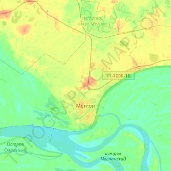
Nombre: Mapa topográfico Megion, altitud, relieve.
Altitud media: 43 m
Altitud mínima: 32 m
Altitud máxima: 61 m