
Mapa topográfico Saint-Étienne
Mapa interactivo
Haga clic en el mapa para ver la altitud.
Acerca de este mapa
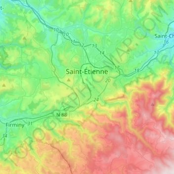
Nombre: Mapa topográfico Saint-Étienne, altitud, relieve.
Altitud media: 669 m
Altitud mínima: 358 m
Altitud máxima: 1 264 m
The climate is temperate at the weather station due to its low altitude, but Saint-Étienne itself is much higher, above 530 m (1,739 ft) in the centre, as well as even above 700 m (2,297 ft) in the southern parts of the city. Saint-Étienne is very close from a warm-summer humid continental climate (Köppen: Dfb); it is generally one of the snowiest cities in France, with an average of 85 cm (2.79 ft) of snow accumulation per year.
Otros mapas topográficos
Haga clic en un mapa para ver su topografía, su altitud y su relieve.
La Tourette
France > Auvergne-Rhône-Alpes > Loire
La Tourette, Montbrison, Loire, Auvergne-Rhône-Alpes, Metropolitan France, 42380, France
Altitud media: 775 m
Chavand
France > Auvergne-Rhône-Alpes > Loire > Saint-Martin-Lestra
Chavand, Saint-Martin-Lestra, Montbrison, Loire, Auvergne-Rhône-Alpes, Metropolitan France, 42110, France
Altitud media: 551 m