
Mapa topográfico Abraham Lake
Mapa interactivo
Haga clic en el mapa para ver la altitud.
Abraham Lake
The Government of Alberta sponsored a contest to name the lake in February 1972, during the final stages of construction of the Bighorn Dam. Students across the province were asked to submit names taking into consideration "historical significance, prominent persons, geography and topography, and the value of the lake." It was eventually named after Silas Abraham (c. 1870–1964), of the Stoney Nakoda First Nation and originally from Morley, Alberta. He was a farmer and hunter who lived in the Kootenay Plains and later on the Big Horn 144A reserve.
Acerca de este mapa
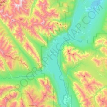
Nombre: Mapa topográfico Abraham Lake, altitud, relieve.
Lugar: Abraham Lake, Census Division No. 9, Alberta, Canada (52.07360 -116.48898 52.33277 -116.32587)
Altitud media: 1 886 m
Altitud mínima: 1 222 m
Altitud máxima: 3 095 m
Otros mapas topográficos
Haga clic en un mapa para ver su topografía, su altitud y su relieve.