
Haz una donación
Mapa topográfico Tamaqua
Haga clic en el mapa para ver la altitud.
Haz una donación
Tamaqua
Tamaqua's average elevation is 870 feet (270 m) above sea level, but elevations can reach up to 1,000 feet (300 m) above sea level.
Haz una donación
Acerca de este mapa
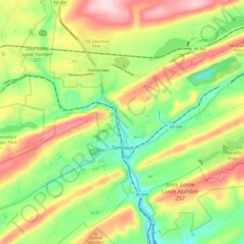
Nombre: Mapa topográfico Tamaqua, altitud, relieve.
Altitud media: 353 m
Altitud mínima: 222 m
Altitud máxima: 521 m
Haz una donación
Otros mapas topográficos
Haga clic en un mapa para ver su topografía, su altitud y su relieve.
Haz una donación
Blue Mountain
United States > Pennsylvania > Schuylkill County > Washington Township
The ridge of Blue Mountain runs for 150 miles (240 km) through Pennsylvania, reaching an elevation of 2,270 feet (690 m) above sea level just north of the Pennsylvania Turnpike, near the borough of Newburg. Most of the ridgecrest, however, only reaches between 1,400 and 1,700 feet (430 and 520 m) in elevation.…
Altitud media: 226 m
Nuremberg
United States > Pennsylvania > Schuylkill County > North Union Township
Altitud media: 377 m