
Haz una donación
Mapa topográfico Dale
Haga clic en el mapa para ver la altitud.
Haz una donación
Acerca de este mapa
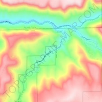
Nombre: Mapa topográfico Dale, altitud, relieve.
Lugar: Dale, Grant County, Oregon, United States (44.96845 -118.96841 45.00845 -118.92841)
Altitud media: 1 035 m
Altitud mínima: 834 m
Altitud máxima: 1 214 m
Haz una donación
Otros mapas topográficos
Haga clic en un mapa para ver su topografía, su altitud y su relieve.
Canyon City
United States > Oregon > Grant County
The city is at an elevation of about 3,200 feet (980 m). Between Canyon City and Burns, to the south, Route 395 passes through parts of the Malheur National Forest. According to the United States Census Bureau, the town has a total area of 1.41 square miles (3.65 km2), all land.
Altitud media: 1 078 m
Haz una donación
Canyon City
United States > Oregon > Grant County > Canyon City
The city is at an elevation of about 3,200 feet (980 m). Between Canyon City and Burns, to the south, Route 395 passes through parts of the Malheur National Forest. According to the United States Census Bureau, the town has a total area of 1.41 square miles (3.65 km2), all land.
Altitud media: 1 078 m