
Mapa topográfico Schnidehorn
Mapa interactivo
Haga clic en el mapa para ver la altitud.
Acerca de este mapa
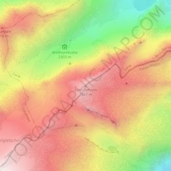
Nombre: Mapa topográfico Schnidehorn, altitud, relieve.
Lugar: Schnidehorn, Ayent, Hérens, Wallis, 1966, Switzerland (46.37302 7.39274 46.37312 7.39284)
Altitud media: 2 566 m
Altitud mínima: 1 975 m
Altitud máxima: 2 992 m
Otros mapas topográficos
Haga clic en un mapa para ver su topografía, su altitud y su relieve.
Lac de Tseuzier
Switzerland > Wallis > Hérens > Ayent
Lac de Tseuzier, Ayent, Hérens, Wallis, 1966, Switzerland
Altitud media: 1 871 m
Bonnefille
Switzerland > Wallis > Hérens > Ayent > Anzère
Bonnefille, Anzère, Ayent, Hérens, Wallis, 1972, Switzerland
Altitud media: 1 408 m
Wildhorn
Switzerland > Wallis > Hérens > Ayent
Wildhorn, Ayent, Hérens, Wallis, 1966, Switzerland
Altitud media: 2 768 m
Anzère
Switzerland > Wallis > Hérens > Ayent
Anzère, Ayent, Hérens, Wallis, 1972, Switzerland
Altitud media: 1 493 m