
Haz una donación
Mapa topográfico Wales Center
Haga clic en el mapa para ver la altitud.
Haz una donación
Acerca de este mapa
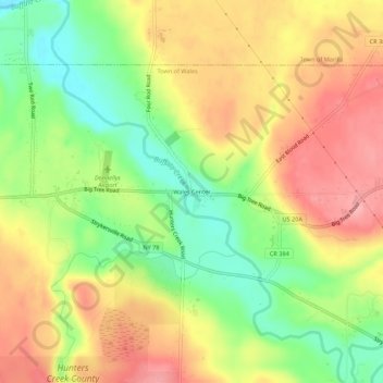
Nombre: Mapa topográfico Wales Center, altitud, relieve.
Altitud media: 317 m
Altitud mínima: 256 m
Altitud máxima: 373 m
Haz una donación
Otros mapas topográficos
Haga clic en un mapa para ver su topografía, su altitud y su relieve.
Erie Canal
United States > New York > Erie County > City of Tonawanda
The construction of the Erie Canal was a landmark civil engineering achievement in the early history of the United States. When built, the 363-mile (584 km) canal was the second-longest in the world (after the Grand Canal in China). Initially 40 feet (12 m) wide and 4 feet (1.2 m) deep, the canal was expanded…
Altitud media: 177 m
Haz una donación
Haz una donación
Haz una donación
Eighteen Mile Creek (Erie County)
United States > New York > Erie County > Highland-on-the-Lake
Altitud media: 194 m
Haz una donación
Haz una donación
Lakeview Road Town Recreation Area
United States > New York > Erie County > Town of Hamburg
Altitud media: 231 m
Haz una donación
Onondaga Escarpment
United States > New York > Erie County > Harris Hill > Town of Clarence > Eastern Hills
Altitud media: 205 m
Haz una donación
Village of Lancaster
United States > New York > Erie County > Village of Lancaster
Altitud media: 209 m
Haz una donación