
Haz una donación
Mapa topográfico Stissing
Haga clic en el mapa para ver la altitud.
Haz una donación
Acerca de este mapa
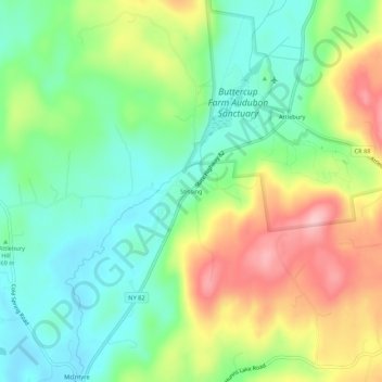
Nombre: Mapa topográfico Stissing, altitud, relieve.
Altitud media: 180 m
Altitud mínima: 115 m
Altitud máxima: 284 m
Haz una donación
Otros mapas topográficos
Haga clic en un mapa para ver su topografía, su altitud y su relieve.
Rhinecliff
United States > New York > Dutchess County > Town of Rhinebeck
The hamlet is demarcated by large agricultural and wooded area to the north, east, and south, and bounded by the Hudson River on the west. Steep topography, formed by contorted slate ridges and valleys, define the site-specific and seemingly random orientation of the small, frame nineteenth-century houses and…
Altitud media: 19 m
Haz una donación
Haz una donación
Drayton Grant Park at Burger Hill
United States > New York > Dutchess County > Town of Rhinebeck
Altitud media: 102 m
Stissing Mountain Multiple Use Area
United States > New York > Dutchess County > Town of Pine Plains
Altitud media: 217 m
Haz una donación
Haz una donación
United States of America Property
United States > New York > Dutchess County > Village of Pawling
Altitud media: 251 m
Haz una donación
Haz una donación