
Haz una donación
Mapa topográfico Millersville
Haga clic en el mapa para ver la altitud.
Haz una donación
Acerca de este mapa
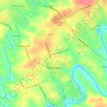
Nombre: Mapa topográfico Millersville, altitud, relieve.
Altitud media: 97 m
Altitud mínima: 61 m
Altitud máxima: 135 m
Haz una donación
Otros mapas topográficos
Haga clic en un mapa para ver su topografía, su altitud y su relieve.
Reinholds
United States > Pennsylvania > Lancaster County > West Cocalico Township
Altitud media: 159 m
Welsh Mountain Nature Preserve
United States > Pennsylvania > Lancaster County > East Earl Township
Altitud media: 294 m
Haz una donación
Holland Heights
United States > Pennsylvania > Lancaster County > East Lampeter Township
Altitud media: 101 m
Haz una donación
Haz una donación
Drumore Center
United States > Pennsylvania > Lancaster County > Drumore Township
Altitud media: 175 m
Haz una donación
Welsh Mountain
United States > Pennsylvania > Lancaster County > Caernarvon Township
Altitud media: 233 m
Brooklawn
United States > Pennsylvania > Lancaster County > Manheim Township > Neffsville
Altitud media: 116 m
Haz una donación
Chestnut Ridge
United States > Pennsylvania > Lancaster County > Rohrerstown > Chestnut Ridge
Altitud media: 122 m
Haz una donación
Greenland
United States > Pennsylvania > Lancaster County > East Lampeter Township
Altitud media: 112 m
Farmdale
United States > Pennsylvania > Lancaster County > West Hempfield Township
Altitud media: 131 m
McGovernsville
United States > Pennsylvania > Lancaster County > East Hempfield Township > Rohrerstown
Altitud media: 109 m
Haz una donación
Reinholds
United States > Pennsylvania > Lancaster County > West Cocalico Township
Altitud media: 159 m
Haz una donación