
Haz una donación
Mapa topográfico Ludwigsburg
Haga clic en el mapa para ver la altitud.
Haz una donación
Acerca de este mapa
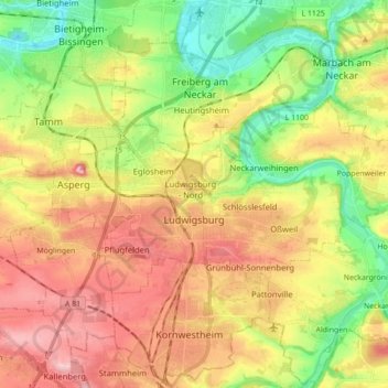
Nombre: Mapa topográfico Ludwigsburg, altitud, relieve.
Lugar: Ludwigsburg, Landkreis Ludwigsburg, Baden-Württemberg, Germany (48.87342 9.13743 48.93256 9.31248)
Altitud media: 266 m
Altitud mínima: 181 m
Altitud máxima: 358 m
Haz una donación
Otros mapas topográficos
Haga clic en un mapa para ver su topografía, su altitud y su relieve.
Rielingshausen
Germany > Baden-Württemberg > Landkreis Ludwigsburg > Marbach am Neckar
Altitud media: 291 m
Nussdorf
Germany > Baden-Württemberg > Landkreis Ludwigsburg
The municipality (Gemeinde) of Eberdingen is located at the western extremity of the district of Ludwigsburg, in the German state of Baden-Württemberg, along its border with the districts of Böblingen and the Enz. Eberdingen is physically located in the basin of [de] the Neckar. Elevation above sea level in…
Altitud media: 321 m
Haz una donación