
Mapa topográfico The Rockies
Mapa interactivo
Haga clic en el mapa para ver la altitud.
Acerca de este mapa
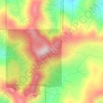
Nombre: Mapa topográfico The Rockies, altitud, relieve.
Lugar: The Rockies, Lewis County, Washington, United States (46.65645 -122.36377 46.65655 -122.36367)
Altitud media: 1 012 m
Altitud mínima: 699 m
Altitud máxima: 1 283 m
Otros mapas topográficos
Haga clic en un mapa para ver su topografía, su altitud y su relieve.
Ceres
United States > Washington > Lewis County
Ceres, Lewis County, Washington, United States
Altitud media: 123 m
Toledo
United States > Washington > Lewis County
Toledo, Lewis County, Washington, United States
Altitud media: 49 m
Riffe Lake
United States > Washington > Lewis County
Riffe Lake, Lewis County, Washington, United States
Altitud media: 503 m
Mossyrock
United States > Washington > Lewis County
Mossyrock, Lewis County, Washington, United States
Altitud media: 213 m
Ike Kinswa State Park
United States > Washington > Lewis County
Ike Kinswa State Park, Lewis County, Washington, United States
Altitud media: 187 m
Chehalis
United States > Washington > Lewis County
Chehalis, Lewis County, Washington, United States
Altitud media: 81 m
Centralia
United States > Washington > Lewis County
Centralia, Lewis County, Washington, United States
Altitud media: 74 m
Winlock
United States > Washington > Lewis County
Winlock, Lewis County, Washington, United States
Altitud media: 124 m
Ham Hill
United States > Washington > Lewis County > Centralia
Ham Hill, Centralia, Lewis County, Washington, United States
Altitud media: 101 m
Napavine
United States > Washington > Lewis County > Napavine
Napavine, Lewis County, Washington, 98565, United States
Altitud media: 105 m
Onalaska
United States > Washington > Lewis County
Onalaska, Lewis County, Washington, 98542, United States
Altitud media: 170 m