
Mapa topográfico Utah County
Mapa interactivo
Haga clic en el mapa para ver la altitud.
Acerca de este mapa
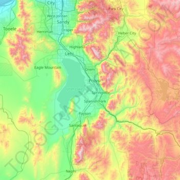
Nombre: Mapa topográfico Utah County, altitud, relieve.
Lugar: Utah County, Utah, United States of America (39.77736 -112.21283 40.57791 -110.85765)
Altitud media: 2 062 m
Altitud mínima: 1 283 m
Altitud máxima: 3 581 m
Utah Valley lies at the center of the county, lined by the mountains of the Wasatch Range on the east. Utah Lake occupies a large part of the valley. The elevation ranges from 4,487 feet (1,368 m) above sea level at the lake to 11,928 feet (3,636 m) at the peak of Mount Nebo.
Otros mapas topográficos
Haga clic en un mapa para ver su topografía, su altitud y su relieve.
Box Elder County
United States of America > Utah
Box Elder County, Utah, United States of America
Altitud media: 1 519 m
Ephraim
United States of America > Utah > Ephraim
Ephraim, Utah, 84627, United States of America
Altitud media: 1 700 m
Levan
United States of America > Utah > Levan
Levan, Utah, United States of America
Altitud media: 1 624 m
Pioneer Stadium
United States of America > Utah > Ogden
Pioneer Stadium, Ogden, Weber County, Utah, United States of America
Altitud media: 1 327 m
Tooele County
United States of America > Utah
Tooele County, Utah, United States of America
Altitud media: 1 462 m
Fielding
United States of America > Utah > Fielding > Fielding
Fielding, Box Elder County, Utah, 84311, United States of America
Altitud media: 1 329 m
Daggett County
United States of America > Utah
Daggett County, Utah, 84023, United States of America
Altitud media: 2 267 m
Duchesne County
United States of America > Utah
Duchesne County, Utah, United States of America
Altitud media: 2 408 m