
Haz una donación
Mapa topográfico West Plattsburgh
Haga clic en el mapa para ver la altitud.
Haz una donación
Acerca de este mapa
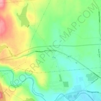
Nombre: Mapa topográfico West Plattsburgh, altitud, relieve.
Altitud media: 146 m
Altitud mínima: 97 m
Altitud máxima: 226 m
Haz una donación
Otros mapas topográficos
Haga clic en un mapa para ver su topografía, su altitud y su relieve.
Lake Roxanne
United States > New York > Clinton County > Town of Ellenburg > Ellenburg Depot
Altitud media: 280 m
Haz una donación
Altona
United States > New York > Clinton County > Town of Altona
The hamlet of Altona is located in the northern part of the town of Altona at 44°53′24″N 73°39′9″W / 44.89000°N 73.65250°W / 44.89000; -73.65250 (44.890096, -73.65272). The Great Chazy River flows along the southeastern edge of the hamlet, dropping 150 feet (46 m) in elevation in 1.7 miles…
Altitud media: 196 m
Haz una donación
Haz una donación
Haz una donación
Haz una donación
Haz una donación
Haz una donación
Plattsburg Boat Launch
United States > New York > Clinton County > City of Plattsburgh
Altitud media: 36 m
Upper Chateaugay Lake Sandbar
United States > New York > Clinton County > Town of Ellenburg
Altitud media: 417 m
Haz una donación