
Haz una donación
Mapa topográfico Raton Pass
Haga clic en el mapa para ver la altitud.
Haz una donación
Raton Pass
Ratón Pass is a 7,834 ft (2,388 m) elevation mountain pass on the Colorado–New Mexico border in the western United States. It is located on the eastern side of the Sangre de Cristo Mountains between Trinidad, Colorado and Raton, New Mexico, approximately 180 miles (290 km) northeast of Santa Fe. Ratón is Spanish for "mouse". The pass crosses the line of volcanic mesas that extends east from the Sangre de Cristo Mountains along the state line, and furnishes the most direct land route between the valley of the Arkansas River to the north and the upper valley of the Canadian River, leading toward Santa Fe, to the south. The pass now carries Interstate 25 and railroad tracks.
Haz una donación
Acerca de este mapa
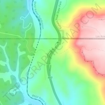
Nombre: Mapa topográfico Raton Pass, altitud, relieve.
Lugar: Raton Pass, Colfax County, New Mexico, United States (36.99017 -104.48280 36.99027 -104.48270)
Altitud media: 2 398 m
Altitud mínima: 2 263 m
Altitud máxima: 2 617 m
Haz una donación
Otros mapas topográficos
Haga clic en un mapa para ver su topografía, su altitud y su relieve.